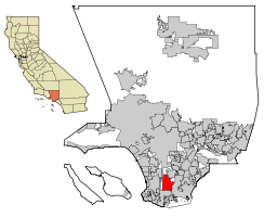
Carson, California
| City of Carson | |||
|---|---|---|---|
| — City — | |||
|
|||
| Motto: Future Unlimited | |||
 |
|||
| Coordinates: | |||
| Country | |||
| State | |||
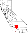
| County | Los Angeles | ||
| Incorporated (city) | November 20, 1968[1] | ||
| Government | |||
| - Type | Council-Manager | ||
| - City Council | Jim Dear[2] Mayor Mike A. Gipson Harold C. Williams Elito M. Santarina Lula Davis-Holmes |
||
| - City Treasurer | Karen Avilla, CCMT | ||
| - City Clerk | Helen S. Kawagoe | ||
| Area | |||
| - Total | 18.97 sq mi (49.12 km2) | ||
| - Land | 18.84 sq mi (48.80 km2) | ||
| - Water | 0.12 sq mi (0.32 km2) 0.65% | ||
| Elevation | 27 ft (8.2 m) | ||
| Population (2009)[3] | |||
| - Total | 92,255 | ||
| - Density | 4,762.2/sq mi (1,838.7/km2) | ||
| Time zone | PST (UTC-8) | ||
| - Summer (DST) | PDT (UTC-7) | ||
| ZIP Code | 90745, 90746, 90747, 90749, 90810, 90895[4] | ||
| Area code(s) | 310/424[5] | ||
| FIPS code | 06-11530[6] | ||
| GNIS feature ID | 1660441[7] | ||
| Website | http://ci.carson.ca.us/ | ||
Carson is a city in Los Angeles County, California. As of the 2009 census, Carson had a total population of 92,255. It is located 13 miles south of downtown Los Angeles, and is known as a suburb of the city[8]. Incorporated on February 20, 1968, Carson is the youngest municipality in the South Bay region of Greater Los Angeles.
Contents |
Geography
Carson is located at (33.839684, -118.259588).[9]
According to the United States Census Bureau, the city has a total area of 49.1 km² (19.0 mi²). 48.8 km² (18.8 mi²) of it is land and 0.3 km² (0.1 mi²) of it (0.63%) is water.
Carson is bordered by West Compton on the north, Compton on the northeast, Long Beach on the east, Wilmington on the south, and West Carson and Harbor Gateway on the west.
Demographics
| Historical populations | |||
|---|---|---|---|
| Census | Pop. | %± | |
| 1960 | 38,059 |
|
|
| 1970 | 71,150 | 86.9% | |
| 1980 | 81,221 | 14.2% | |
| 1990 | 83,995 | 3.4% | |
| 2000 | 89,730 | 6.8% | |
| source:[10][11] | |||
As of the census[6] of 2000, there were 89,730 people, 24,648 households, and 20,236 families residing in the city. The population density was 1,838.9/km² (4,762.2/mi²). There were 25,337 housing units at an average density of 519.2/km² (1,344.7/mi²). The racial makeup of the city was 25.69% White, 25.41% Black or African American, 0.56% Native American, 22.27% Asian, 2.99% Pacific Islander, 17.98% from other races, and 5.09% from two or more races. 34.92% of the population were Hispanic or Latino of any race.
There were 24,648 households out of which 39.2% had children under the age of 18 living with them, 58.7% were married couples living together, 17.2% had a female householder with no husband present, and 17.9% were non-families. 14.2% of all households were made up of individuals and 5.9% had someone living alone who was 65 years of age or older. The average household size was 3.59 and the average family size was 3.92.
Age ranges of residents were 28.4% under the age of 18, 9.9% from 18 to 24, 28.5% from 25 to 44, 22.5% from 45 to 64, and 10.7% who were 65 years of age or older. The median age was 34 years. For every 100 females there were 93.3 males. For every 100 females age 18 and over, there were 89.4 males.
According to a 2006 estimate, the median income for a household in the city was $60,457, and the median income for a family was $66,468.[12] Males had a median income of $33,579 versus $31,110 for females. The per capita income for the city was $17,107. About 7.2% of families and 9.3% of the population were below the poverty line, including 10.9% of those under age 18 and 8.6% of those age 65 or over. Carson has the distinction of being the only incorporated city in the United States where the African American population has a higher median income than the white population.[13]
Government and infrastructure
Local government
According to the city’s most recent Comprehensive Annual Financial Report, the city’s various funds had $96.3 million in Revenues, $81.8 million in expenditures, $611.4 million in total assets, $129.2 million in total liabilities, and $187.2 million in cash and investments.[14]
County, state, and federal representation
Fire protection in Carson is provided by the Los Angeles County Fire Department which operates out of Fire Stations 10, 36, 116 and 127. Ambulance transportation is provided by McCormick Ambulance Service Station 17.[15] The Los Angeles County Sheriff's Department (LASD) operates the Carson Station in Carson.[16]
The Los Angeles County Department of Health Services operates the Torrance Health Center in Harbor Gateway, Los Angeles, near Torrance and serving Carson.[17]
In the state legislature Carson is located in the 28th Senate District, represented by Democrat Jenny Oropeza, and in the 55th Assembly District, represented by Democrat Warren T. Furutani. Federally, Carson is located in California's 37th congressional district, which has a Cook PVI of D +27[18] and is represented by Democrat Laura Richardson.
The United States Postal Service operates the Carson Post Office at 21350 Avalon Boulevard and the South Bay Pavilion Station in Suite 116 at 20700 Avalon Boulevard.[19][20]
Education
Primary and secondary schools
Public Schools in Carson served by the Los Angeles Unified School District include 232nd Place Elementary School, Catskill Elementary School, Carson Street Elementary School, Caroldale Learning Community, Del Amo Elementary School, Dolores Elementary School, Dominguez Elementary School, Andrew Carnegie Middle School, Stephen M. White Middle School, Broadacres Elementary, Leapwood Avenue Elementary School, Annalee Avenue Elementary School, Curtiss Middle School and Ambler Avenue Elementary School. Towne Avenue Elementary School
High schools serving portions of Carson include Carson High School and Banning High School. The area is within Board District 8.[21] As of 2008 Dr. Richard Vladovic represents the district.[22]
Some portions of Carson are in the Compton Unified School District.
Although the California Academy of Mathematics and Science is located in Carson, it is actually a part of the Long Beach Unified School District. The school accepts residents of LBUSD, Compton USD, portions of LAUSD (including sections serving Carson), and other districts.
Public libraries
County of Los Angeles Public Library operates the Carson Regional Library and the Dr. Martin Luther King Library. Both libraries are in Carson.
Transportation
The city operates the Carson Circuit [1] bus that serves the local community and connects to other bus services and the Del Amo Station, as well as the North-South Shuttle [2] which connects Carson to the Artesia Transit Center.
Sports
| Club | League | Venue | Established | Championships |
|---|---|---|---|---|
| Los Angeles Galaxy | MLS Soccer | The Home Depot Center | 1995 | 2 |
| Chivas USA | MLS Soccer | The Home Depot Center | 2004 | 0 |
| Los Angeles Sol | WPS Women's Soccer | The Home Depot Center | 2009 | 0 |
| Carson Buzz | ABA Basketball | Veterans Park Sports Complex | 2004 | 0 |
| Los Angeles Riptide | MLL Lacrosse | The Home Depot Center Track Field | 2006 | 0 |
Attractions
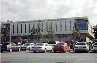
Carson is the site of California State University, Dominguez Hills (CSUDH). CSUDH is a major commuter school, particularly for African-American students from the surrounding cities of Long Beach, Gardena, and Compton. It was established in the wake of the 1965 Watts riots, as a response to community outcry over the lack of higher education opportunities in the largely black south suburbs of Los Angeles. Today it is among the most racially diverse campuses in the United States. Prior to expansion in the mid 1960s, the university was located in nearby Palos Verdes. In 1965, Carson was chosen as the home for the relocating university over the communities of Friendship Park, Fort MacArthur and Torrance. Carson is also home to the Home Depot Center which is the home of the Los Angeles Galaxy soccer team and hosts the yearly JP Morgan/Chase tennis tournament.
Carson is also the location of the Home Depot Center, a sports complex including a soccer-specific stadium used by the Los Angeles Galaxy, the Los Angeles Sol, and as of 2005, Chivas USA, a tennis stadium and a track and field facility. It is also the default home ground for the United States men's national soccer team. It opened in 2003, adjacent to CSUDH. The ADT Event Center is the only permanent indoor velodrome in the U.S. In July 2007, the Galaxy signed international soccer superstar David Beckham to the team.
The Goodyear Blimp also has a landing pad in Carson, a fitting tribute to the 1st and 2nd U.S. and International Aviation Meets held at the Dominguez Hill Rancho in 1910 and 1911, which featured many blimps and zeppelins.
Economy
See's Candies has an office at 20600 South Alameda Street in Carson.[23]
Oil History
1921 marked the first drilling for oil at Dominguez Hill, on the northwest side of the Dominguez Rancho, site of the famous battle during the Mexican-American War called the Battle of Dominguez Rancho in 1846. The mineral rights to this property were owned by Carson Estate Company, the Hellman Family, the Dominguez Estate Company, and the Burnham Exploration Company of Frederick Russell Burnham. It wasn't long before a number of refineries were up and running, with over 350 oil derricks, tank farms, and sprawling industrial complexes becoming a familiar part of the scenery. The principal leases were with Shell Oil Company and Union Oil of California and the first two wells were located west of Central Avenue and north of Victoria Street. Oil led to an increase in jobs in the community and a subsequent post-war population surge. An average of 300 barrels a day was produced from these wells through 1960.
Shopping
Carson is home to the Pavilion at South Bay shopping mall, located at the Avalon Boulevard exit off the San Diego Freeway (Interstate 405). Tenant stores include Sears, Ikea, Target, and 24 Hour Fitness.
An outdoor power center/entertainment complex called Carson Marketplace has been planned but is not yet built. It is on a site once proposed for a stadium that could have played host to a National Football League team (see History of National Football League in Los Angeles for details). Construction has been delayed by the need for an extensive environmental cleanup, as this was once a toxic waste dump.
Notable residents
- Forest Whitaker, director, producer, and Academy Award–winning actor
- Juanita Millender-McDonald, Democratic U.S. Congresswoman from 1996–2007
- Brandy, singer/actress
- Ray J (Willie Norwood, Jr.), singer/actor
- Ras Kass, rapper
- The Regulators, Rock Group
- Boo-Yaa T.R.I.B.E., Rap Group
- The Game (Jayceon Taylor), rapper. Lived in Carson from the ages of 7 to 15 while in foster care
- Tommy "Tiny" Lister, actor and former professional wrestler
- Kia Stevens, also known as Awesome Kong and Amazing Kong in TNA Wrestling - a professional wrestler
- Chad Brown, National Football League Umpire
- Bishop Lamont, rapper
- Dr. Dre (Andre Young, Sr.), rapper/producer. Lived in Carson during his middle school years
- Ekene Ibekwe, University of Maryland forward
- Tammy Townsend, television actress
- Chuckii Booker, singer, songwriter
- The Boys, late 1980s R&B quartet
- Courtney Hall, former San Diego Chargers Center & Guard 1989–1999
- SoShy, ( Deborah Epstein ), a French singer and songwriter.
Movies/TV shows filmed in Carson
- 24 (Used CSUDH but was referenced on the show as UCSB)
- Reno 911! [3]
- Reno 911!: Miami
- Jackie Brown (film) [4]
- Gone in 60 Seconds
- Emergency! (Station 127 of the Los Angeles County Fire Department)
- Evolution
- Joe Dirt
- Pros vs Joes
- 10 Items or Less
- The Cable Guy
- Certified Gangstas (2004) Music video from rapper, Jim Jones
- Colors
- Welcome Home, Roxy Carmichael (Winona Ryder, Jeff Daniels)
- Vega$ (portions of TV show)
- Gwen Stefani's "Hollaback Girl" Video (S.M. White Middle School Drill & Carson Flaggies)
- Hey Mickey music video (Carson High Cheer)
- Entourage (Season 4 Episode 6 Card Convention at the Carson Community Center)
See also
- Carson Community Center
References
- ↑ "Incorporation Dates of California Cities". http://www.cacities.org/resource_files/20457.IncorpDateLO.doc. Retrieved 2007-01-18.
- ↑ "Elected Officials - City of Carson". http://ci.carson.ca.us/content/government/members.asp. Retrieved 2007-01-18.
- ↑ "Carson city, California - Fact Sheet - American FactFinder". http://factfinder.census.gov/servlet/ACSSAFFFacts?_event=Search&geo_id=&_geoContext=&_street=&_county=&_cityTown=Carson&_state=04000US06&_zip=&_lang=en&_sse=on&pctxt=fph&pgsl=010. Retrieved 2007-01-18.
- ↑ "USPS - ZIP Code Lookup - Find a ZIP+ 4 Code By City Results". http://zip4.usps.com/zip4/zcl_1_results.jsp?visited=1&pagenumber=0&state=ca&city=Carson. Retrieved 2007-01-18.
- ↑ "Number Administration System - NPA and City/Town Search Results". http://www.nanpa.com/nas/public/npa_city_query_step2.do?method=displayData&cityToNpaModel.stateAbbr=CA&cityToNpaModel.city=Carson. Retrieved 2007-01-18.
- ↑ 6.0 6.1 "American FactFinder". United States Census Bureau. http://factfinder.census.gov. Retrieved 2008-01-31.
- ↑ "US Board on Geographic Names". United States Geological Survey. 2007-10-25. http://geonames.usgs.gov. Retrieved 2008-01-31.
- ↑ http://www.hospitalsoup.com/listing/56686-clarion-los-angeles
- ↑ "US Gazetteer files: 2000 and 1990". United States Census Bureau. 2005-05-03. http://www.census.gov/geo/www/gazetteer/gazette.html. Retrieved 2008-01-31.
- ↑ "CENSUS OF POPULATION AND HOUSING (1790-2000)". U.S. Census Bureau. http://www.census.gov/prod/www/abs/decennial/index.html. Retrieved 2010-07-30.
- ↑ Census figure enumerated in 1960 was prior to incorporation.
- ↑ http://factfinder.census.gov/servlet/ACSSAFFFacts?_event=Search&geo_id=16000US0608954&_geoContext=01000US%7C04000US06%7C16000US0608954&_street=&_county=carson&_cityTown=carson&_state=04000US06&_zip=&_lang=en&_sse=on&ActiveGeoDiv=geoSelect&_useEV=&pctxt=fph&pgsl=160&_submenuId=factsheet_1&ds_name=ACS_2006_SAFF&_ci_nbr=null&qr_name=null®=null%3Anull&_keyword=&_industry= factfinder.census.gov
- ↑ "Carson - Income". http://www.epodunk.com/cgi-bin/incomeOverview.php?locIndex=9966. Retrieved 2007-05-07.
- ↑ City of Carson CAFR Retrieved 2009-08-18
- ↑ McCormick Ambulance Service Station Locations
- ↑ "Carson Station." Los Angeles County Sheriff's Department. Retrieved on January 21, 2010.
- ↑ "Torrance Health Center." Los Angeles County Department of Health Services. Retrieved on March 18, 2010.
- ↑ "Will Gerrymandered Districts Stem the Wave of Voter Unrest?". Campaign Legal Center Blog. http://www.clcblog.org/blog_item-85.html. Retrieved 2008-02-10.
- ↑ "Post Office Location - CARSON." United States Postal Service. Retrieved on December 6, 2008.
- ↑ "Post Office Location - SOUTHBAY PAVILION STATION." United States Postal Service. Retrieved on December 6, 2008.
- ↑ Board District 7 Map. Los Angeles Unified School District. Retrieved on November 24, 2008.
- ↑ "Board Members." Los Angeles Unified School District. Retrieved on November 24, 2008.
- ↑ "Contact Us." See's Candies. Retrieved on January 18, 2009.
External links
- Carson official website
- LA County Disaster Communication Service (DCS) Carson Sheriff Station
- Carson High School page
|
||||||||||||||||||||